
1. Chapter at a Glance
A resource is anything in our environment that can satisfy our needs, provided it is technologically accessible, economically feasible and culturally acceptable. Resources are not free gifts of nature alone — they become resources through human activity, and humans themselves are an essential resource. This chapter classifies resources, explains why resource planning and sustainable development matter, studies land as a resource, land degradation and its conservation, and the major soils of India with methods of soil conservation.
Nature + Technology + Institutions → Resources. Indiscriminate use of resources has led to depletion, concentration of wealth in a few hands, and global problems such as global warming, ozone depletion, pollution and land degradation.
2. Classification of Resources
| Basis | Types | Examples |
|---|---|---|
| Origin | Biotic (living) / Abiotic (non-living) | Forests, animals, humans / rocks, metals, water |
| Exhaustibility | Renewable / Non-renewable | Solar, wind, water, forests / fossil fuels, minerals (some recyclable like metals; some not, like coal) |
| Ownership | Individual / Community / National / International | Own farm, house / village pond, grazing ground / minerals, forests, roads within borders / ocean resources beyond 200 nautical miles (EEZ) |
| Status of development | Potential / Developed / Stock / Reserves | Rajasthan and Gujarat solar and wind / resources surveyed and in use / hydrogen in water (no technology yet) / water in dams, forests (part of stock usable with present technology) |
Stock: materials that could satisfy needs but which we lack the technology to use (e.g., using hydrogen and oxygen of water as energy on a large scale). Reserves: a subset of stock that can be used with existing technology but whose use has not yet started — kept for the future (e.g., water in dams, forest reserves).
3. Development and Resource Planning
Sustainable development means development that meets present needs without compromising the ability of future generations to meet theirs. The Earth Summit at Rio de Janeiro (1992) adopted the Rio Declaration, the Convention on Climate Change and Agenda 21 — a global plan to combat environmental damage, poverty and disease through cooperation, with local action at every level.
Resource planning in India
India has enormous diversity in resource availability: Jharkhand, Madhya Pradesh and Chhattisgarh are rich in minerals and coal; Arunachal Pradesh has abundant water but little infrastructure; Rajasthan is rich in solar and wind energy but short of water; Ladakh is cold desert with rich cultural heritage but little water and infrastructure. So planning is needed at national, state, regional and local levels.
- Identify and inventory resources through surveys, mapping and qualitative and quantitative estimation.
- Evolve a planning structure with the right technology, skill and institutions.
- Match resource plans with overall national development plans.
India began resource planning with the First Five Year Plan (1951). Gandhiji summed up the conservation idea: "There is enough for everybody's need and not for anybody's greed." The Club of Rome (1968), Schumacher's Small is Beautiful (1974) and the Brundtland Commission Report "Our Common Future" (1987) shaped global thinking on conservation.
4. Land Resources and Land Use
India's land is varied: about 43% plains (agriculture and industry), 30% mountains (perennial rivers, tourism, ecology) and 27% plateaus (minerals, fossil fuels, forests).
| Land-use category | Includes |
|---|---|
| Forests | Area under forest cover |
| Land not available for cultivation | Barren and wasteland; land under non-agricultural uses (buildings, roads, factories) |
| Other uncultivated land (excluding fallow) | Permanent pastures and grazing land; land under miscellaneous tree crops and groves; cultivable wasteland (left uncultivated for more than 5 years) |
| Fallow lands | Current fallow (left for one year or less); other fallow (1–5 years) |
| Net sown area | Area actually sown in a year; area sown more than once added gives gross cropped area |
The total geographical area of India is about 3.28 million sq km, but land-use data are available for only about 93% of it (as the textbook notes, data for most of the north-east except Assam and for parts of J&K occupied by Pakistan and China were not reported). Net sown area is about half the reporting area, but varies widely — over 80% in Punjab and Haryana, under 10% in Arunachal Pradesh, Mizoram, Manipur and the Andaman and Nicobar Islands. The National Forest Policy (1952) set a goal of 33% of geographical area under forest; actual forest cover is well below that.
5. Land Degradation and Conservation
| Cause of degradation | Where (examples) |
|---|---|
| Mining (deep scars, overburden left behind) | Jharkhand, Chhattisgarh, Madhya Pradesh, Odisha |
| Overgrazing | Gujarat, Rajasthan, Madhya Pradesh, Maharashtra |
| Over-irrigation (waterlogging → salinity and alkalinity) | Punjab, Haryana, western Uttar Pradesh |
| Mineral processing dust (e.g., grinding limestone for cement, calcite and soapstone for ceramics) | Industrial areas |
| Industrial effluents and deforestation | Many regions |
About 130 million hectares of land in India is degraded (as given in the NCERT textbook; about 28% of it forest degraded land, 56% water-eroded, the rest saline/alkaline). Remedies: afforestation, proper management of grazing, planting shelter belts, stabilising sand dunes with thorny bushes, managing wasteland, controlling mining, and treating industrial effluents before release.
6. Soil as a Resource
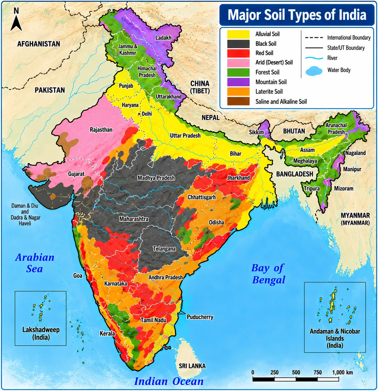
Soil is the most important renewable natural resource — the medium of plant growth. It forms over millions of years from parent rock through weathering by temperature changes, running water, wind and glaciers, and the action of decomposers. Relief, parent rock, climate, vegetation and time decide its type. A few centimetres of soil can take hundreds of years to form.
| Soil | Where | Features | Crops |
|---|---|---|---|
| Alluvial (most widespread) | Northern plains (Indus, Ganga, Brahmaputra), Gujarat, eastern coastal deltas (Mahanadi, Godavari, Krishna, Kaveri) | Deposited by rivers; sand, silt, clay; Khadar (new, finer, more fertile) and Bangar (old, with kankar nodules); rich in potash, phosphoric acid, lime | Sugarcane, paddy, wheat, pulses |
| Black (regur) | Deccan trap — Maharashtra, Saurashtra, Malwa, Madhya Pradesh, Chhattisgarh; Godavari and Krishna valleys | Formed from basalt lava; fine clay; holds moisture; rich in calcium carbonate, magnesium, potash, lime; poor in phosphorus; develops deep cracks in summer (self-aeration); sticky when wet | Cotton ("black cotton soil") |
| Red and yellow | Eastern and southern Deccan (low rainfall areas of crystalline igneous rock), Odisha, Chhattisgarh, middle Ganga plain, piedmont of Western Ghats | Red due to iron diffusion; yellow when hydrated | Millets, pulses (with fertilisers) |
| Laterite | Karnataka, Kerala, Tamil Nadu, Madhya Pradesh, hilly Odisha and Assam | High temperature and heavy rain → intense leaching; acidic; low in humus | With conservation: tea, coffee (Karnataka, Kerala, TN); cashew (red laterite, Tamil Nadu, AP, Kerala) |
| Arid | Western Rajasthan | Red to brown; sandy, saline; low humus and moisture; lower layers have kankar due to calcium | Cultivable with irrigation (as in western Rajasthan) |
| Forest | Hilly and mountainous forested areas | Loamy and silty in valleys, coarse on slopes; acidic and low in humus at higher altitudes; fertile on lower valley parts | Varies |
7. Soil Erosion and Conservation
Soil erosion is the removal of topsoil by running water, wind or human action. Running water cuts deep channels called gullies; land made unfit by gullies is bad land — in the Chambal basin such land is called ravines. When water flows as a sheet over large areas, washing away topsoil, it is sheet erosion. Wind blows away loose soil from flat or sloping land — wind erosion. Deforestation, overgrazing, construction, mining and faulty farming (ploughing up and down slopes) speed up erosion.
| Method | How it helps |
|---|---|
| Contour ploughing | Ploughing along contour lines slows water flow down slopes |
| Terrace farming | Steps cut on slopes restrict erosion — common in the western and central Himalaya |
| Strip cropping | Strips of grass between crops break wind force |
| Shelter belts | Rows of trees stabilise sand dunes and stop wind erosion in western India |
In Sukhomajri village (Haryana) and Jhabua district (Madhya Pradesh), communities reversed land degradation through watershed management. In Jhabua, Bhil tribal communities revived large areas of degraded common land. In Sukhomajri, villagers stopped open grazing in return for a share of the water and fodder — showing that people's participation is key to conservation.
8. Master Table: Key Terms
| Term | Meaning |
|---|---|
| Resource | Useful, accessible, feasible, acceptable material |
| Potential resource | Found but not yet utilised |
| Stock | Usable only with future technology |
| Reserves | Usable now but saved for future |
| Net sown area | Area sown in a year |
| Gross cropped area | Net sown area + area sown more than once |
| Fallow land | Cultivable land left unsown to regain fertility |
| Khadar / Bangar | New / old alluvium |
| Regur | Black cotton soil |
| Leaching | Washing out of nutrients by heavy rain |
| Bad land / ravines | Land cut up by gullies |
| Agenda 21 | Rio 1992 plan for sustainable development |
9. Master Summary Table
| Soil | Key region | Key crop | Key feature |
|---|---|---|---|
| Alluvial | Northern plains | Wheat, rice, sugarcane | Most fertile and widespread |
| Black | Deccan plateau | Cotton | Moisture-retentive, cracks |
| Red-yellow | Eastern/southern Deccan | Millets, pulses | Iron gives red colour |
| Laterite | Western Ghats, hills | Tea, coffee, cashew | Leached, acidic |
| Arid | Western Rajasthan | With irrigation | Sandy, saline, kankar |
| Forest | Hills | Varies | Acidic at heights |
Chart — India's relief (% of area):
10. Mind Map
- Origin, exhaustibility
- Ownership, development
- Rio 1992, Agenda 21
- 3 steps
- Land use categories
- Degradation causes
- Alluvial, black, red
- Laterite, arid, forest
- Contour, terraces
- Strips, shelter belts
11. Tips and Tricks
- Resource test "TEC": Technologically accessible, Economically feasible, Culturally acceptable.
- Khadar = Kid (new), Bangar = Buddha (old, wise, with kankar).
- Black soil = Basalt + Boll (cotton boll).
- Reserves are part of the stock, not the other way round.
- Black soil is poor in phosphorus but rich in lime, potash and magnesium.
- Over-irrigation causes salinity — in Punjab and Haryana, not in dry Rajasthan.
12. Important One-liners
- Agenda 21 was signed at the Rio Earth Summit, 1992.
- India's first Five Year Plan began in 1951.
- Alluvial soil is the most widespread soil in India.
- Black soil is also called regur.
- Laterite soil forms by intense leaching.
- Ravines are found in the Chambal basin.
- Terrace farming is common in the Himalaya.
- Shelter belts check wind erosion in western India.
- Ocean resources beyond 200 nautical miles are international.
- Punjab and Haryana have the highest share of net sown area.
- Mining has degraded land in Jharkhand and Odisha.
13. Previous-Year-Pattern Questions with Detailed Answers
Which soil is ideal for growing cotton?
- Laterite
- Black
- Alluvial
- Arid
Show answer
Black (regur) soil holds moisture and is rich in lime, potash and magnesium — ideal for cotton. Laterite suits tea/coffee/cashew; alluvial suits rice, wheat, sugarcane; arid soil needs irrigation.
Answer: (B)
Land degradation in Punjab and Haryana is mainly due to:
- Mining
- Overgrazing
- Over-irrigation
- Deforestation
Show answer
Excessive irrigation causes waterlogging, raising salinity and alkalinity. Mining affects Jharkhand/Odisha; overgrazing affects Gujarat/Rajasthan.
Answer: (C)
Distinguish between stock and reserves.
Show answer
Stock: resources that could meet needs but cannot be used for lack of technology (e.g., hydrogen in water as fuel). Reserves: part of the stock usable with current technology but kept for future use (e.g., water in dams, forests).
Answer: Technology gap vs saved for future
Why is resource planning essential in India?
Show answer
Resources are unevenly distributed — some States are rich in minerals but poor in water (or vice versa). Without planning there is waste, regional imbalance, depletion and conflict. Planning at national, state and local levels ensures balanced development, sustainable use and matching resources with technology and institutions.
Answer: Diversity and limits of resources demand balanced, sustainable use
Describe four features of alluvial soil.
Show answer
(1) Deposited by Indus, Ganga and Brahmaputra and found in deltas of the east coast. (2) Contains sand, silt and clay; coarser in the upper river valleys and near the foothills. (3) Divided into Khadar (new, fertile) and Bangar (old, with kankar). (4) Rich in potash, phosphoric acid and lime; supports sugarcane, paddy, wheat and pulses, so these areas are densely populated.
Answer: River-deposited, fertile, Khadar/Bangar
Explain three methods of soil conservation used on slopes and in deserts.
Show answer
Contour ploughing slows runoff on slopes; terrace farming creates steps that hold water and soil in hills; shelter belts of trees and strip cropping with grass reduce wind speed and erosion in dry, sandy areas.
Answer: Contour ploughing, terraces, shelter belts/strips
Classify resources on the basis of ownership with examples.
Show answer
Individual (privately owned farms, houses, wells); Community (village grazing grounds, ponds, playgrounds); National (all resources within political boundaries — minerals, forests, roads; government can acquire private property for public good); International (ocean resources beyond 200 nautical miles of the EEZ, regulated by international institutions).
Answer: Individual, community, national, international
"Land degradation is mainly a result of human activity." Justify with examples and suggest remedies.
Show answer
Mining leaves deep pits and overburden (Jharkhand, Odisha); overgrazing strips vegetation (Gujarat, Rajasthan); over-irrigation causes salinity (Punjab, Haryana); mineral processing dust settles on land; deforestation and industrial effluents damage soil. Remedies: afforestation, regulated grazing, shelter belts, sand-dune stabilisation, wasteland management, mining controls and effluent treatment.
Answer: Mining, grazing, irrigation, industry — controllable through management
Compare black and laterite soils.
Show answer
Black: formed from basalt lava of the Deccan; clayey and moisture-retentive; rich in calcium, magnesium, potash; poor in phosphorus; suits cotton. Laterite: formed under high temperature and heavy rain by leaching; acidic, low in humus and nutrients; useful for tea, coffee and cashew only with manure and conservation.
Answer: Fertile lava soil vs leached acidic soil
What lessons do Sukhomajri and Jhabua offer for resource conservation?
Show answer
Both show that degraded land can be revived when local people manage common resources through watershed development and fair benefit sharing. Villagers protected slopes and gave up open grazing in return for water and fodder; tribal communities revived common land. Lesson: community participation, local institutions and equitable sharing are as important as technology.
Answer: People's participation makes conservation work
Explain the concept of sustainable development and the significance of Agenda 21.
Show answer
Sustainable development meets present needs without harming the ability of future generations to meet theirs — balancing economy, environment and society. Agenda 21, adopted at the 1992 Rio Earth Summit, is a global action plan to fight environmental damage, poverty and disease through shared interests and mutual needs; every local government was to draw up its own local Agenda 21.
Answer: Inter-generational balance; global plan with local action
14. Quick Revision Summary
- Resources: biotic/abiotic; renewable/non-renewable; individual/community/national/international; potential/developed/stock/reserves.
- Rio 1992, Agenda 21; resource planning in three steps; Gandhi: need, not greed.
- Land: 43% plains, 30% mountains, 27% plateaus; land use categories; net sown vs gross cropped area.
- Degradation: mining, overgrazing, over-irrigation, dust, effluents; remedies.
- Soils: alluvial (Khadar/Bangar), black (cotton), red-yellow, laterite (leached), arid (kankar), forest.
- Erosion: gullies, ravines, sheet and wind erosion; contour ploughing, terraces, strips, shelter belts; Sukhomajri, Jhabua.