
1. Chapter at a Glance
Goods and services do not move on their own. Transport carries goods and people from where they are produced to where they are needed; communication carries messages and ideas; and trade exchanges goods between people, States and countries. An efficient, fast network of transport and communication is a pre-requisite for local, national and global trade — these are the lifelines of the national economy. This chapter covers roadways, railways, pipelines, waterways and ports, airways, communication, international trade and tourism.
2. Roadways
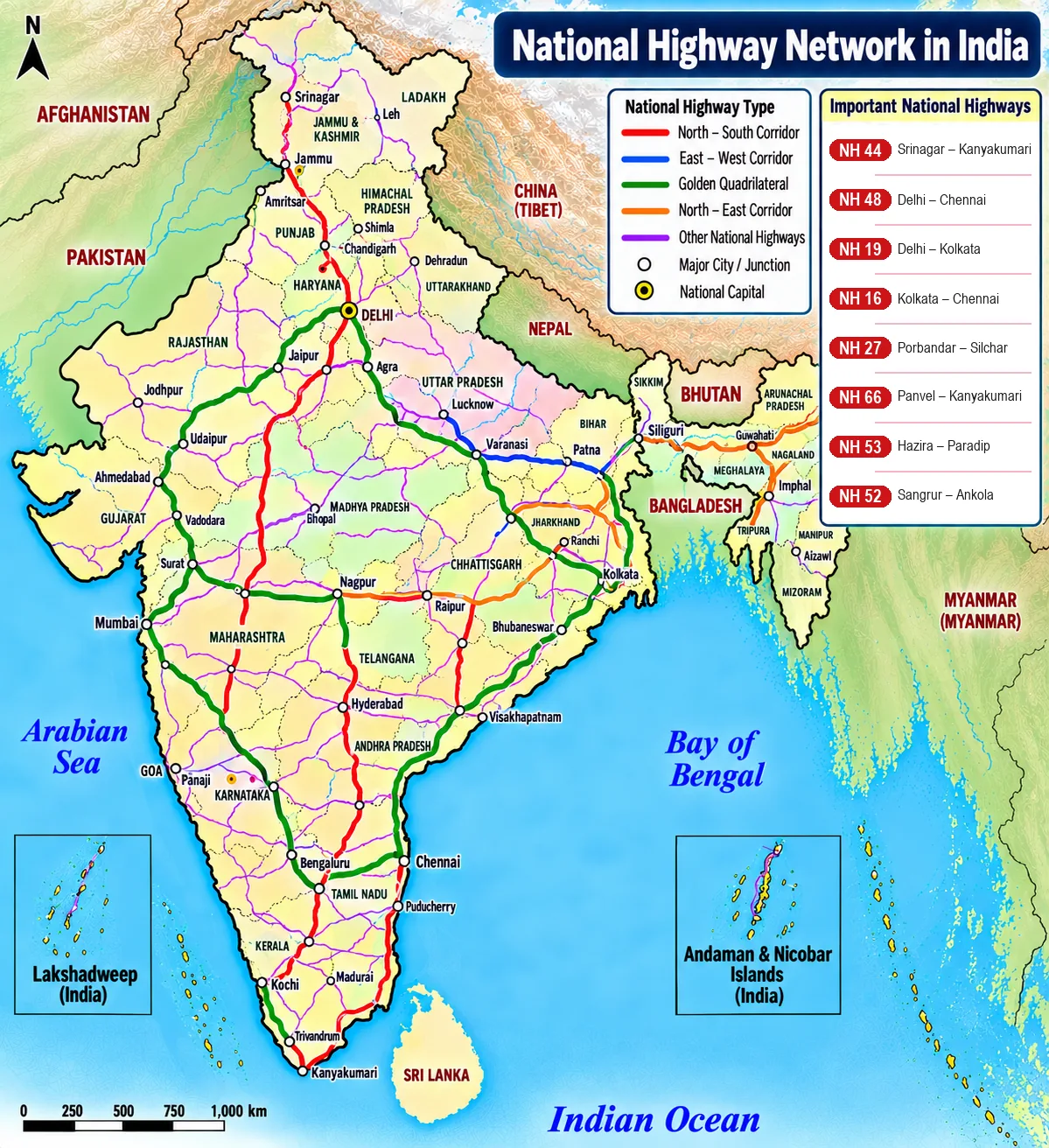
India has one of the largest road networks in the world (over 60 lakh km). Roads are preferred over railways for short distances because they cost less to build, can cross hilly and dissected terrain, carry fewer people and smaller loads economically over short distances, provide door-to-door service, and act as feeders to railways, ports and airports.
| Road type | Built and maintained by | Features |
|---|---|---|
| Golden Quadrilateral super highways | National Highways Authority of India (NHAI) | Six-lane highways linking Delhi–Kolkata–Chennai–Mumbai–Delhi; with the North–South corridor (Srinagar–Kanyakumari) and East–West corridor (Silchar–Porbandar), they cut travel time and distance between megacities |
| National highways | Central Public Works Department (CPWD) / NHAI | Link extreme parts of the country; primary road system |
| State highways | State Public Works Department (PWD) | Link a State capital with district headquarters |
| District roads | Zila Parishad | Connect district headquarters with other places in the district |
| Other (rural) roads | Under special schemes like PMGSY (Pradhan Mantri Grameen Sadak Yojana) | Link villages with towns; all-weather roads to every village |
| Border roads | Border Roads Organisation (BRO), set up in 1960 | Strategic roads in northern and north-eastern border areas; high-altitude roads; also help economic development |
Road density is the length of road per 100 sq km of area; it is high in the plains and low in mountainous and desert regions such as J&K and Rajasthan. Problems: inadequate network for traffic volume, many unmetalled roads that become unusable in rains, narrow and congested highways, and bridges and culverts that are old and narrow.
3. Railways
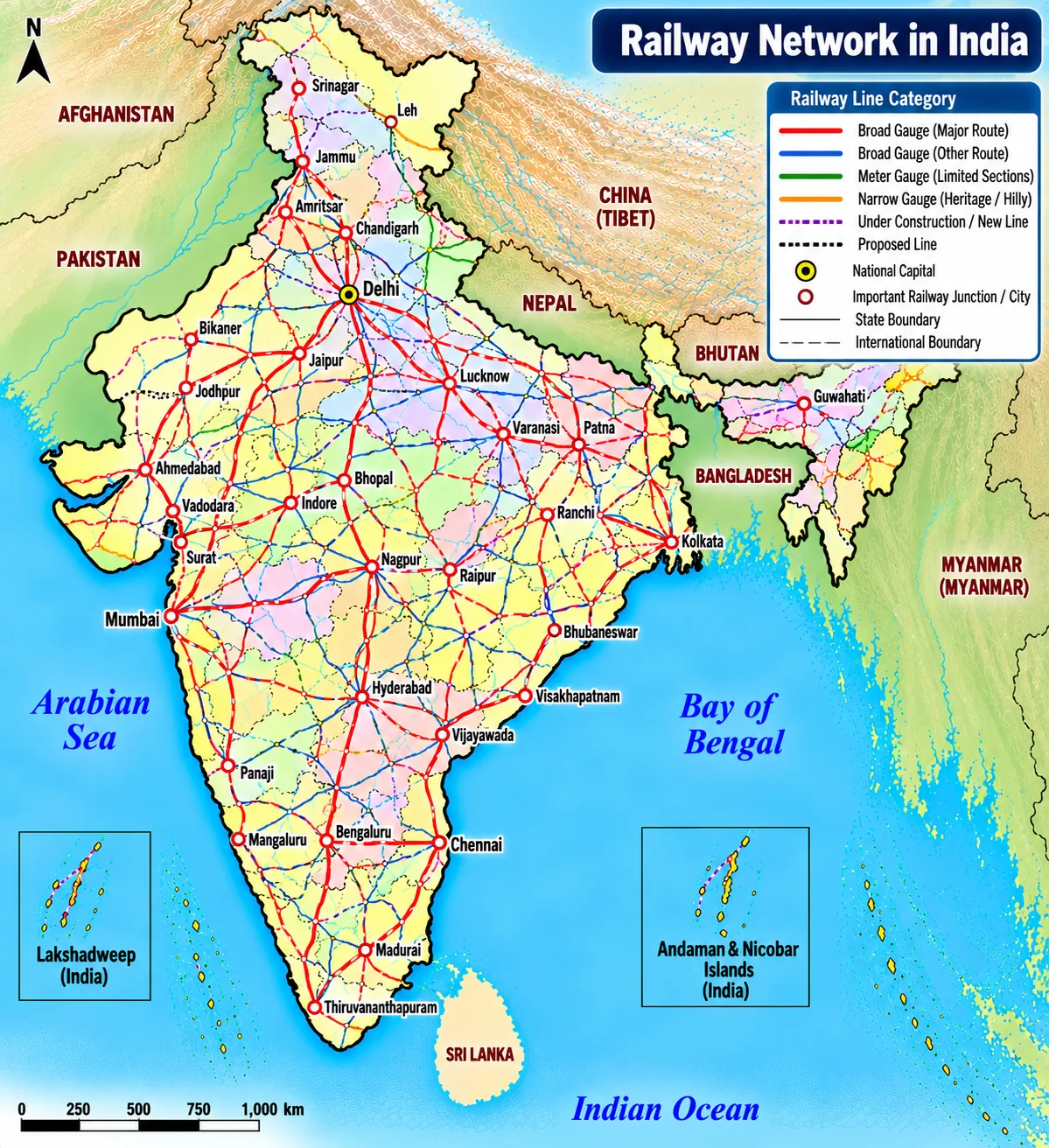
Railways are the principal mode of transport for freight and passengers in India. They conduct many activities — business, sightseeing, pilgrimage and long-distance movement of goods. Indian Railways is one of the largest railway networks in the world, organised into zones.
| Gauge | Width |
|---|---|
| Broad gauge | 1.676 m — most of the network today |
| Metre gauge | 1.000 m |
| Narrow gauge | 0.762 m and 0.610 m — mostly hill and heritage lines |
- Northern plains: vast level land, high population density and rich agriculture — the most favourable conditions; but many rivers need bridges.
- Peninsula: hilly terrain; railways pass through low hills, gaps or tunnels.
- Himalaya: high relief, sparse population and few economic opportunities make lines difficult; similarly in the sandy plains of western Rajasthan, swamps of Gujarat and forests of MP, Chhattisgarh, Odisha and Jharkhand.
- The Konkan Railway (1998) along the west coast is a major achievement — about 760 km from Roha (Maharashtra) to Mangaluru (Karnataka) through Goa, crossing a great many rivers and streams on bridges and cutting through the Western Ghats in tunnels. Problems include sinking of track and landslides.
- Problems of railways: ticketless travel, theft and damage to railway property, unnecessary chain-pulling.
4. Pipelines
Pipelines carry crude oil, petroleum products and natural gas from fields to refineries, fertiliser factories and power plants; solids can be moved as slurry. Initial cost is high but running costs are minimal, and they avoid trans-shipment losses and delays.
| Network | Route |
|---|---|
| Upper Assam oil fields | To Kanpur (UP) via Guwahati, Barauni and Allahabad (Prayagraj); branches Barauni–Haldia (via Rajbandh), Rajbandh–Maurigram and Guwahati–Siliguri |
| Salaya (Gujarat) | To Jalandhar (Punjab) via Viramgam, Mathura, Delhi and Sonipat; branch to Koyali (near Vadodara) and others |
| Gas pipeline | Hazira (Gujarat) to Jagdishpur (UP) via Vijaipur (MP) — the HVJ pipeline; branches to Kota, Shahjahanpur, Babrala and others |
5. Waterways and Ports
Water transport is the cheapest for heavy and bulky goods; it is fuel-efficient and environment-friendly. India has about 14,500 km of navigable waterways.
| National Waterway | Stretch | Length |
|---|---|---|
| NW 1 | Ganga: Allahabad (Prayagraj)–Haldia | 1,620 km |
| NW 2 | Brahmaputra: Sadiya–Dhubri | 891 km |
| NW 3 | West Coast Canal in Kerala (Kottapuram–Kollam, with Udyogamandal and Champakkara canals) | 205 km |
| NW 4 | Specified stretches of Godavari and Krishna with Kakinada–Puducherry canal | 1,078 km |
| NW 5 | Brahmani, Matai, Mahanadi delta channels and East Coast Canal | 588 km |
In 2016 the government declared over 100 more national waterways. Other inland routes include the Mandovi, Zuari and Cumberjua, Sunderbans, Barak and Kerala backwaters.
Major sea ports
India's coastline is about 7,516.6 km long (textbook figure) with 12 major and many minor ports; they handle most of India's foreign trade by volume.
| Port | Coast | Feature |
|---|---|---|
| Kandla (Deendayal), Kachchh | West | First port developed after independence to ease Mumbai and replace Karachi lost at Partition; a tidal port; serves the granary and industrial belt of the north |
| Mumbai | West | Largest port with a spacious natural, well-sheltered harbour; Jawaharlal Nehru Port was built to decongest it and serve as a hub |
| Marmagao (Goa) | West | Premier iron ore exporting port — about half of India's iron ore exports (textbook) |
| New Mangalore | West | Exports iron ore concentrates from Kudremukh |
| Kochi | West | South-western port at the entrance of a lagoon with a natural harbour |
| Tuticorin (V.O. Chidambaranar) | East | Natural harbour; trade with Sri Lanka, Maldives and coastal India |
| Chennai | East | One of the oldest artificial ports; second to Mumbai in trade and cargo volume |
| Visakhapatnam | East | Deepest land-locked and well-protected port; originally developed to export iron ore |
| Paradip (Odisha) | East | Specialises in iron ore exports |
| Kolkata | East | Inland riverine port on the Hugli; tidal; needs constant dredging; Haldia developed as a subsidiary port to relieve it |
6. Airways
Air travel is the fastest, most comfortable and prestigious mode. It can cover very difficult terrain — high mountains, dreary deserts, dense forests and long oceans — so it is vital for the north-eastern States with their big rivers, dissected relief and forests. Air transport was nationalised in 1953. Pawan Hans Helicopters Ltd. provides helicopter services to ONGC offshore operations, to inaccessible areas and hilly terrain in the north-east and the interior of J&K, Himachal Pradesh and Uttarakhand. Air travel is beyond the reach of many, though schemes like UDAN (2016) aim to make regional flights affordable.
7. Communication
- Indian postal network is the largest in the world. First-class mail (cards and envelopes) is airlifted between stations covering both land and air; second-class mail (book packets, registered newspapers and periodicals) goes by surface mail — land and water transport.
- Six mail channels for quick delivery in large towns and cities: Rajdhani Channel, Metro Channel, Green Channel, Business Channel, Bulk Mail Channel and Periodical Channel.
- India has one of the largest telecom networks in the world, with mobile and internet services reaching most villages; Subscriber Trunk Dialling (STD) facilities spread widely in earlier decades.
- Mass communication: radio (All India Radio / Akashvani), television (Doordarshan), newspapers and periodicals in many languages, films (India is one of the world's largest film producers; the Central Board of Film Certification certifies films) — they provide entertainment, create awareness and spread information.
8. International Trade and Tourism
Exchange of goods among people, States and countries is trade; the market is where it happens. Trade between two countries is international trade, by sea, air or land. The difference between exports and imports is the balance of trade: if exports exceed imports it is favourable; if imports exceed exports it is unfavourable. No country can survive without trade; advancement in international trade is an index of economic prosperity and is called the "economic barometer" of a country.
| Exports (examples) | Imports (examples) |
|---|---|
| Engineering goods, petroleum products, gems and jewellery, chemicals, pharmaceuticals, agricultural products (rice, spices), textiles, IT and software services | Crude oil and petroleum products, electronic goods, gold and precious stones, machinery, chemicals, coal, edible oils, fertilisers |
India has become a software and IT services hub, earning large foreign exchange. Tourism is also a trade: it earns foreign exchange, gives direct and indirect jobs (handicrafts, hotels, transport, guides), promotes national integration and international understanding. Foreign tourists come for heritage, eco-tourism, adventure, culture, medical and business tourism.
9. Master Table: Key Terms
| Term | Meaning |
|---|---|
| Golden Quadrilateral | Highways linking Delhi, Kolkata, Chennai, Mumbai |
| Road density | Road length per 100 sq km |
| BRO | Border Roads Organisation (1960) |
| Gauge | Distance between the two rails |
| Tidal port | Port usable with high tide (e.g., Kandla) |
| Riverine port | Port on a river inland (Kolkata) |
| Land-locked harbour | Harbour enclosed by land (Visakhapatnam) |
| HVJ pipeline | Hazira–Vijaipur–Jagdishpur gas line |
| Balance of trade | Exports minus imports |
| Favourable balance | Exports greater than imports |
| Mass communication | Media reaching many people at once |
10. Master Summary Table
| Mode | Strength | Weakness |
|---|---|---|
| Road | Door-to-door, cheap to build, any terrain | Congestion, poor quality in places |
| Rail | Bulk goods, long distance, cheap per km | Fixed routes; hard in mountains |
| Pipeline | Low running cost, no trans-shipment losses | High initial cost; fixed |
| Water | Cheapest for bulky goods, eco-friendly | Slow; depends on rivers and ports |
| Air | Fastest; reaches difficult terrain | Expensive |
Chart — National Waterways (length, km):
11. Mind Map
- GQ, NS–EW corridors
- BRO, PMGSY
- Gauges, Konkan
- HVJ, Salaya–Jalandhar
- NW 1–5
- 12 major ports
- 1953, Pawan Hans
- Mail channels
- Balance of trade
- Tourism, IT
12. Tips and Tricks
- Golden Quadrilateral "D-K-C-M": Delhi, Kolkata, Chennai, Mumbai (clockwise).
- Corridors: N–S = Srinagar to Kanyakumari; E–W = Silchar to Porbandar.
- NW lengths: "Ganga is 1620, Brahmaputra 891".
- Ports west to east: K-M-M-N-K then T-C-V-P-K.
- Kolkata is a riverine port, not a coastal one; Haldia is its subsidiary.
- Kandla was the first port developed after independence.
- Chennai is an artificial port; Visakhapatnam is the deepest land-locked one.
13. Important One-liners
- The Border Roads Organisation was set up in 1960.
- Broad gauge is 1.676 m wide.
- The Konkan Railway opened in 1998.
- NW 1 runs from Prayagraj to Haldia.
- Kandla is a tidal port.
- Mumbai has the largest natural harbour.
- Marmagao is the premier iron ore exporting port.
- Visakhapatnam is the deepest land-locked port.
- Air transport was nationalised in 1953.
- India's postal network is the largest in the world.
- Trade is called the economic barometer of a country.
14. Previous-Year-Pattern Questions with Detailed Answers
The first port developed after independence was:
- Mumbai
- Kandla
- Chennai
- Kolkata
Show answer
Kandla (Kachchh) was developed to ease pressure on Mumbai and replace Karachi lost at Partition. Mumbai, Chennai and Kolkata existed earlier.
Answer: (B)
Which agency builds roads in border areas?
- NHAI
- CPWD
- BRO
- State PWD
Show answer
The Border Roads Organisation (1960) builds strategic roads in border areas. NHAI and CPWD handle national highways; State PWDs handle State highways.
Answer: (C)
What is a favourable balance of trade?
Show answer
When the value of a country's exports is greater than the value of its imports.
Answer: Exports exceed imports
Why are roads more important than railways for short distances?
Show answer
Roads cost less to build, can climb steep, dissected terrain like the Himalaya, carry few people and small loads economically over short distances, give door-to-door service (reducing loading and unloading), and feed railways, ports and airports.
Answer: Cheaper, flexible, door-to-door, feeders
How does relief affect the distribution of railways in India?
Show answer
The level northern plains with dense population and agriculture have the densest network. The peninsula's hills require tunnels and gaps; the Himalaya's high relief, sparse population and few opportunities make lines difficult; deserts, swamps and dense forests also limit construction. The Konkan coast was crossed only with great engineering effort.
Answer: Plains favour rail; mountains, deserts, forests hinder it
State the advantages of pipelines.
Show answer
After high initial cost, running costs are minimal; they avoid trans-shipment losses and delays; they can carry liquids, gases and even solids as slurry; they allow refineries and fertiliser and power plants to be located inland (e.g., Barauni, Mathura, Panipat); and they can cross difficult terrain.
Answer: Low running cost, no losses, inland industry
Why is air transport preferred in the north-eastern States?
Show answer
Big rivers, dissected relief, dense forests, frequent floods and international borders make building and maintaining roads and railways hard. Air transport crosses such terrain quickly; Pawan Hans helicopters also serve inaccessible areas.
Answer: Difficult terrain for surface transport
"Means of transport and communication are the lifelines of a nation." Explain.
Show answer
They move raw materials to factories and goods to markets, connect producers and consumers, help farmers sell produce, link remote regions, support defence, tourism and trade, carry information and ideas, and bind the country together socially and culturally. Without them production, trade and national integration would stall — just as a body needs blood vessels.
Answer: They connect production, markets and people
Compare Kolkata and Visakhapatnam ports.
Show answer
Kolkata is an inland riverine tidal port on the Hugli, serving the Ganga–Brahmaputra basin; silting needs constant dredging, so Haldia was built as a subsidiary. Visakhapatnam is the deepest land-locked, well-protected port on the east coast, originally developed to export iron ore; it handles large ships easily.
Answer: Shallow river port vs deep protected harbour
Why is international trade called the economic barometer of a country?
Show answer
No country is self-sufficient; trade shows how much a country produces, what it needs and how competitive it is. A growing volume of exports and a healthy balance of trade indicate economic strength, while heavy dependence on imports may signal weakness. So trade trends measure economic prosperity like a barometer measures pressure.
Answer: Trade reflects economic health
How does tourism help India's economy?
Show answer
It earns foreign exchange, gives direct jobs (hotels, guides, transport) and indirect jobs (handicrafts, food), supports local culture and heritage conservation, promotes national integration as people visit other regions, and builds international understanding. Heritage, eco, adventure, medical and business tourism all have scope.
Answer: Foreign exchange, jobs, integration
15. Quick Revision Summary
- Roads: GQ (D-K-C-M), N–S (Srinagar–Kanyakumari), E–W (Silchar–Porbandar); NH, SH, district, rural (PMGSY), border (BRO 1960); road density.
- Rail: gauges 1.676/1/0.762–0.610 m; relief controls spread; Konkan Railway 1998.
- Pipelines: Assam–Kanpur, Salaya–Jalandhar, HVJ.
- Waterways: NW 1–5; ports Kandla (first, tidal), Mumbai, JNPT, Marmagao, New Mangalore, Kochi, Tuticorin, Chennai, Visakhapatnam, Paradip, Kolkata–Haldia.
- Air: nationalised 1953; Pawan Hans; UDAN. Post: first/second class mail, six channels; mass media.
- Trade: balance of trade; economic barometer; tourism and IT services.