
1. Chapter at a Glance
The Earth is wrapped in a thin blanket of air called the atmosphere, held in place by gravity. It gives us oxygen to breathe, blocks harmful ultraviolet rays, keeps the planet warm by trapping some of the Sun's heat, and produces all our weather. This chapter covers what the air is made of, the five layers of the atmosphere, the difference between weather and climate, the elements of weather, India's seasons, the monsoon and how it works, and the growing problem of climate change, with a case study of the 2025 Punjab floods.
- What is the atmosphere made of?
- How do its layers affect life on Earth?
- How does the monsoon work?
- How can each of us shrink our carbon footprint?
2. Composition of the Atmosphere
| Gas | Share by volume (dry air) | Why it matters |
|---|---|---|
| Nitrogen | ~78% | Most abundant; bacteria fix it into soil so plants can make proteins |
| Oxygen | ~21% | Needed for breathing and burning |
| Argon | ~0.93% | Inert (does not react) |
| Carbon dioxide | ~0.04% | Used by plants in photosynthesis; a key greenhouse gas that traps heat |
| Others | Tiny traces | Helium, neon, krypton, xenon, hydrogen, ozone |
Besides these gases, air carries water vapour and dust particles. Water vapour varies a lot from place to place (the textbook gives a typical range of 0.1–0.4%; very humid tropical air can hold far more). It forms clouds and rain. Dust particles act as tiny surfaces on which water vapour condenses. The make-up of air also changes with height — the air gets thinner as we go up.
3. Layers of the Atmosphere
Scientists divide the atmosphere into layers based on how temperature and density change with altitude. Air is densest near the ground and thins out upwards.
| Layer | Height (approx.) | Temperature trend | Key features |
|---|---|---|---|
| Troposphere | Surface to ~12 km on average (higher over the equator, lower over the poles) | Falls with height | Air we breathe, most water vapour and clouds; almost all weather (rain, fog, hail) happens here. Upper boundary: tropopause |
| Stratosphere | Up to ~50 km | Rises with height (ozone absorbs UV) | Contains the ozone layer; calm and cloud-free, so good for jet flights. Boundary: stratopause |
| Mesosphere | Up to ~80 km | Falls with height (coldest layer) | Most meteors burn up here. Boundary: mesopause |
| Thermosphere | ~80 to 700 km | Rises very fast | Gas molecules absorb X-rays and short-wave UV; contains the ionosphere, which reflects radio waves back to Earth; auroras glow here |
| Exosphere | Above ~700 km | — | Extremely thin air; light gases like hydrogen and helium escape into space; many satellites orbit here |
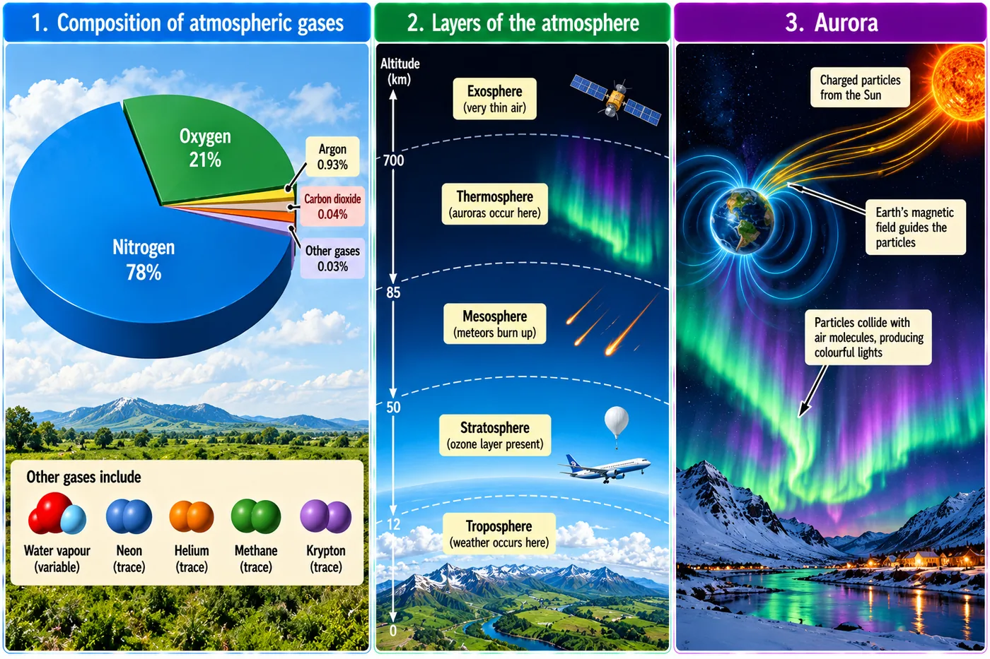
Auroras (from the Latin word for "dawn") are curtains of coloured light near the poles. The solar wind — charged particles from the Sun — is steered by the Earth's magnetic field towards the magnetic poles. When these particles strike gases in the thermosphere, each gas glows in its own colour. In the Northern Hemisphere it is the Aurora Borealis; in the Southern Hemisphere, the Aurora Australis.
Why don't we feel the weight of air? Air presses on us from every side, and the fluids inside our bodies push outward with equal pressure, so the two balance out.
4. Weather and Climate
- Weather — the state of the atmosphere at a place hour to hour and day to day (sunny, rainy, windy, humid).
- Climate — the average weather of a large area over a long period, usually 30 years or more.
Elements of weather and climate
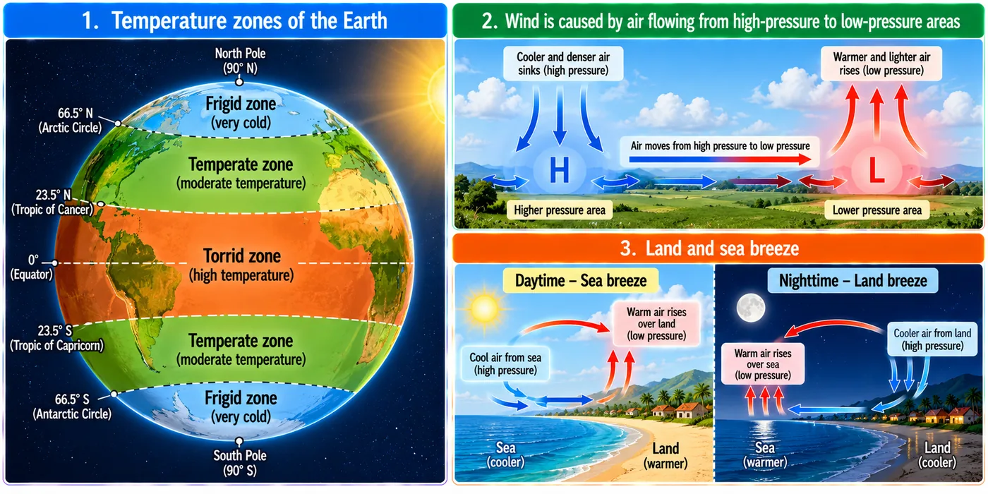
- Temperature: depends mainly on insolation (incoming solar energy received by the Earth). Insolation falls from the equator to the poles, so temperature does too. This gives three heat zones: the Torrid Zone (between the Tropics of Cancer and Capricorn, 23½°N–23½°S), two Temperate Zones (23½° to 66½°) and two Frigid Zones (beyond the Arctic and Antarctic Circles).
- Humidity: the amount of water vapour in the air. Warm air can hold more vapour; on humid days sweat evaporates slowly and clothes take long to dry.
- Precipitation: when air becomes saturated, vapour condenses and falls as drizzle, rain, snow, sleet or hail. It depends on winds, mountains and seasons. Rain recharges groundwater.
- Air pressure: the weight of air on the surface. It is highest at sea level and falls with height. Hot air rises → low pressure (cloudy, wet weather); cold air sinks → high pressure (clear, sunny skies).
- Wind: air moving from high to low pressure; its direction is bent by the Earth's rotation. Winds are named after the direction they come from — a westerly blows from the west.
| Wind | Speed (km/h) | Effect |
|---|---|---|
| Calm | 0–1 | Smoke rises straight up |
| Light breeze | 6–11 | Felt on the face; leaves rustle; wind vane moves |
| Strong breeze | 39–49 | Large branches sway; umbrellas hard to use |
| Storm | 103–117 | Rare; widespread damage |
Land and sea breezes
These local winds keep coastal climates mild. By day, land heats faster than the sea, so low pressure forms over land and a cool sea breeze blows in from the sea (strongest in the afternoon). At night, land cools faster, the sea is warmer, and a gentle land breeze blows out to sea. The land breeze is weaker because the night-time temperature difference is smaller.
5. Seasons of India
India has a tropical monsoon climate. The India Meteorological Department (IMD) recognises four seasons:
| Season | Months | Features |
|---|---|---|
| Winter | December to early April | Coldest in Dec–Jan; about 10–15°C in the north-west, 20–25°C in the south-east |
| Summer (pre-monsoon) | April to June (to July in the north-west) | Hottest month is April in the south and west, May in the north; inland 32–40°C |
| Monsoon (advancing) | June to September | Humid south-west winds bring most of India's rain |
| Post-monsoon (retreating) | October to December | Clear skies in the north-west; rain on the south-east coast |
The Himalayan States also see spring and autumn. Traditionally, Indians counted six ṛtus of about two months each: Vasanta (spring, Mar–Apr), Grīṣhma (summer, May–Jun), Varṣhā (rains, Jul–Aug), Śharad (early autumn, Sep–Oct), Hemanta (late autumn, Nov–Dec) and Śhiśhira (winter, Jan–Feb). Ancient texts show a long interest in weather: the Arthaśhāstra records rainfall measurement for revenue and relief, while the Kṛiṣhiparāśhara and Varāhamihira's Bṛihatsaṁhitā describe ways of forecasting rain. Kālidāsa's Meghadūtam (about 5th century CE) traces the path of monsoon clouds over central India.
6. The Monsoon
The word comes from the Arabic mausim, meaning "season". A monsoon is a seasonal reversal of wind direction during the year. Sailors and Arab traders used these reversing winds to sail to and from India.
South-west (summer) monsoon — June to September
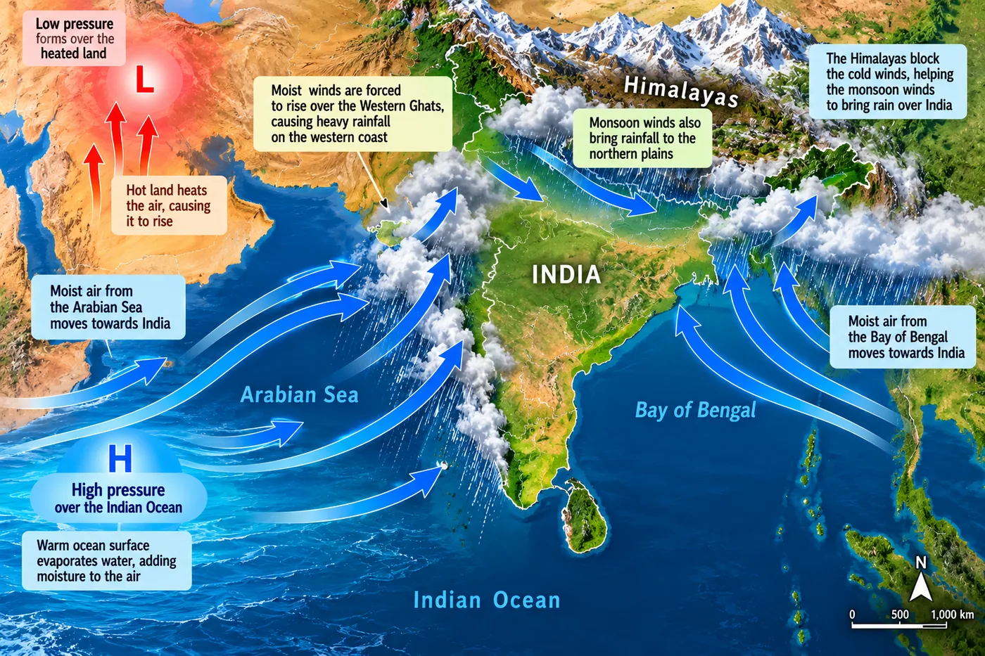
- In summer the Indian landmass heats up faster than the surrounding oceans.
- A low-pressure area forms over the subcontinent; the cooler Indian Ocean has high pressure.
- Moist winds blow from the sea to the land across the Arabian Sea and the Bay of Bengal.
- As they rise over the Western Ghats, the Himalaya and the north-eastern hills, they cool and pour rain. This season gives India most of its yearly rainfall.
The monsoon normally reaches Kerala around 1 June and covers the whole country by about 8 July.
North-east (winter) monsoon — from October
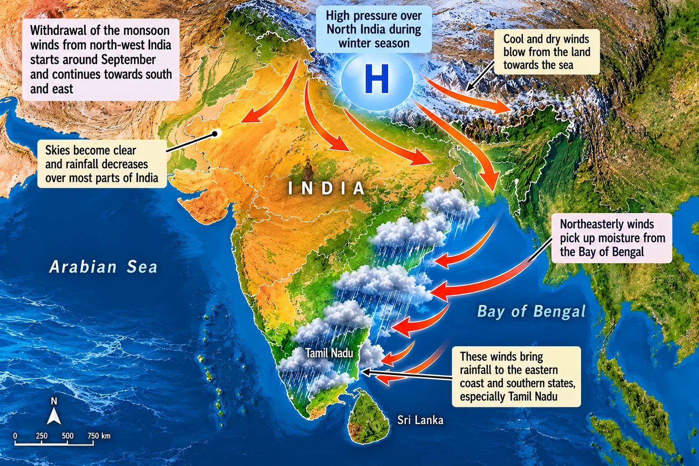
In winter the land cools faster than the sea, so high pressure builds over land and cold, dry winds blow from land to sea. They bring little rain to most of India — but while crossing the Bay of Bengal they pick up moisture and drench the east coast, especially Tamil Nadu, coastal Andhra Pradesh and parts of Karnataka. That is why Chennai gets its heaviest rain in October–November.
The monsoon begins to withdraw from north-west India around 17 September and leaves the country by about 15 October.
- Most Indian farming depends on monsoon rain for sowing and growing crops.
- A good monsoon fills rivers, reservoirs and wells; a weak one causes drought, an excessive one causes floods.
- It affects food prices, jobs, transport, festivals and rural incomes.
- The Ministry of Earth Sciences runs the National Monsoon Mission to improve forecasting models, and Mission Mausam (approved in 2024) aims to make India "Weather Ready" and "Climate Smart".
7. Climate Change
Climate change means long-term shifts in temperature, rainfall and wind patterns, caused mainly by human activities: burning coal, oil and gas, cutting forests and industrial pollution. These add greenhouse gases — carbon dioxide, methane, nitrous oxide — which trap heat and raise global temperatures. Effects include more frequent floods and droughts, melting glaciers, rising sea levels and loss of biodiversity, with serious impacts on health, farming and livelihoods, especially for women, children and the poor.
Your carbon footprint is the total greenhouse gases released by your activities — travel, electricity, water use and waste. You can reduce it by walking, cycling or using public transport; switching off lights and fans; saving water; refusing single-use plastics; reusing and recycling; and planting trees.
Case study: Punjab floods, 2025
| Aspect | Details |
|---|---|
| Natural causes | Very heavy monsoon rain, intensified by western disturbances; heavy rain also in Himachal Pradesh and Jammu & Kashmir; the Satluj, Beas, Ravi and Ghaggar were already running high and then overflowed |
| Human-made causes | Weak, old embankments (dhūsī bāndh); houses and farms built too close to rivers; silt reducing river and dam capacity; late or unclear flood warnings |
| Effects | Loss of lives; thousands moved to relief camps; paddy fields submerged; dairy and poultry farms destroyed; roads, bridges and border fences damaged; waterborne diseases from stagnant water |
| Lessons | Stronger embankments, keeping floodplains free of construction, desilting, timely warnings, and following NDMA flood guidelines |
8. Master Table: Key Terms
| Term | Meaning |
|---|---|
| Atmosphere | Blanket of air around the Earth held by gravity |
| Altitude | Height above mean sea level |
| Tropopause | Boundary between troposphere and stratosphere |
| Ozone layer | Layer in the stratosphere that filters ultraviolet rays |
| Ionosphere | Part of the thermosphere that reflects radio waves |
| Insolation | Incoming solar energy received by the Earth |
| Humidity | Water vapour present in the air |
| Precipitation | Water falling as rain, snow, sleet or hail |
| Monsoon | Seasonal reversal of wind direction |
| Western disturbance | Rain-bearing weather system arriving from the west |
| Carbon footprint | Total greenhouse gases released by a person's activities |
9. Master Summary Table
| Feature | South-west monsoon | North-east monsoon |
|---|---|---|
| Season | June–September | October onwards (winter) |
| Pressure over land | Low | High |
| Wind direction | Sea → land | Land → sea |
| Moisture | Moist | Dry (except after crossing the Bay of Bengal) |
| Rain | Most of India | Mainly Tamil Nadu and the south-east coast |
Chart — gases in dry air (% by volume):
10. Mind Map
- N₂ 78%, O₂ 21%
- Ar, CO₂, vapour, dust
- Tropo, strato, meso
- Thermo, exo
- Temperature, humidity
- Rain, pressure, wind
- SW: June–Sept
- NE: Tamil Nadu rain
- Greenhouse gases
- Punjab floods 2025
11. Tips and Tricks
- Layer order upward: "The Sun Makes The Earth warm" — Troposphere, Stratosphere, Mesosphere, Thermosphere, Exosphere.
- Heights: 12 – 50 – 80 – 700 km.
- Temperature: falls in the Tropo and Meso — the two layers whose names sound "low".
- Breezes: Sea breeze in the Sunshine (day); Land breeze when Lights go out (night).
- Winds are named after where they come from, not where they go.
- Weather is short-term; climate is the 30-year average — don't swap them.
- The ozone layer is in the stratosphere, not the troposphere.
12. Important One-liners
- Nitrogen is the most abundant gas in the atmosphere.
- Almost all weather occurs in the troposphere.
- The ozone layer lies in the stratosphere.
- Meteors burn up mostly in the mesosphere.
- Auroras occur in the thermosphere.
- The ionosphere reflects radio waves back to Earth.
- Climate is the average weather over 30 years or more.
- Air moves from high-pressure to low-pressure areas.
- "Monsoon" comes from the Arabic word mausim.
- The south-west monsoon reaches Kerala around 1 June.
- Tamil Nadu gets much of its rain from the north-east monsoon.
13. Exam-pattern Questions with Detailed Answers
In which layer of the atmosphere does almost all weather occur?
- Stratosphere
- Troposphere
- Mesosphere
- Thermosphere
Show answer
The troposphere holds most water vapour and clouds, so rain, fog, hail and storms happen there. The stratosphere is calm and cloud-free; the mesosphere and thermosphere are far too thin for weather.
Answer: (B)
The ozone layer is found in the:
- Troposphere
- Mesosphere
- Stratosphere
- Exosphere
Show answer
Ozone in the stratosphere absorbs harmful ultraviolet rays, which is also why temperature rises with height in this layer.
Answer: (C)
Why do we not feel the pressure of the atmosphere?
Show answer
Air presses on our bodies from all directions, and the pressure inside our bodies pushes outward equally. The two balance, so we feel no net force.
Answer: Inside and outside pressures are equal
Distinguish between the troposphere and the stratosphere.
Show answer
Troposphere: lowest layer, about 12 km on average; temperature falls with height; contains the air we breathe, water vapour and clouds; all weather happens here. Stratosphere: above it, up to about 50 km; temperature rises with height; contains the ozone layer; free of clouds and storms, so suitable for jet flights.
Answer: Weather layer vs calm ozone layer
Explain the difference between weather and climate with an example.
Show answer
Weather is the day-to-day state of the air — "it is raining in Patna today". Climate is the average pattern over 30 years or more — "Patna has hot summers, a rainy monsoon and cool winters". Weather can change within hours; climate changes only over long periods.
Answer: Short-term condition vs long-term average
Why does a sea breeze blow during the day and a land breeze at night?
Show answer
Land heats and cools faster than water. By day the land is warmer, air over it rises and creates low pressure, so cooler air flows in from the sea (sea breeze). At night the land becomes cooler than the sea, so pressure is higher over land and air flows out to sea (land breeze). The night difference is smaller, so the land breeze is gentler.
Answer: Unequal heating and cooling of land and water
Name the four seasons recognised by the IMD and give their months.
Show answer
Winter (December to early April), summer or pre-monsoon (April to June), monsoon or advancing monsoon (June to September), and post-monsoon or retreating monsoon (October to December).
Answer: Winter, summer, monsoon, post-monsoon
Distinguish between the south-west and the north-east monsoon.
Show answer
South-west: June–September; land heats faster than sea, low pressure over land; moist winds blow from sea to land and give most of India its rain. North-east: from October in winter; land cools faster, high pressure over land; dry winds blow from land to sea, giving little rain except on the Tamil Nadu and south-east coast after picking up moisture over the Bay of Bengal.
Answer: Wind reversal driven by unequal heating of land and sea
Why does Chennai receive most of its rainfall only after the monsoon has ended in most of India?
Show answer
Chennai lies on the east coast in the rain shadow of the Western Ghats, so the south-west winds reach it after losing much of their moisture. In October–December, the north-east winds cross the Bay of Bengal, pick up moisture and shed it on the Tamil Nadu coast. So its main rainy season comes with the retreating/north-east monsoon.
Answer: North-east monsoon picks up moisture over the Bay of Bengal
Were the 2025 Punjab floods caused only by nature? Discuss.
Show answer
Nature supplied the water: very heavy monsoon rain boosted by western disturbances, with heavy rain upstream in Himachal and J&K, so the Satluj, Beas, Ravi and Ghaggar overflowed. But human factors made the damage worse: old, weak embankments, building on floodplains, silted rivers and dams that hold less water, and late warnings. Better planning — strong embankments, desilting, floodplain zoning and early warnings — could have reduced losses.
Answer: Natural trigger, worsened by human factors
Suggest five practical ways a student can reduce their carbon footprint.
Show answer
(1) Walk, cycle or use public transport for short trips. (2) Switch off lights, fans and chargers when not in use. (3) Use water carefully — one bucket for a bath, fix leaking taps. (4) Avoid single-use plastics; reuse and recycle. (5) Plant and care for trees, and encourage family and friends to do the same.
Answer: Less fuel, less power, less waste, more trees
14. Quick Revision Summary
- Air: nitrogen ~78%, oxygen ~21%, argon ~0.93%, CO₂ ~0.04%, plus water vapour and dust.
- Layers: troposphere (weather, ~12 km), stratosphere (ozone, ~50 km), mesosphere (meteors, ~80 km), thermosphere (ionosphere, auroras, to ~700 km), exosphere.
- Weather = daily; climate = 30-year average. Elements: temperature, humidity, precipitation, pressure, wind.
- IMD seasons: winter, summer, monsoon, post-monsoon; six traditional ṛtus.
- Monsoon (mausim): SW June–Sept, sea to land; NE from October, rain to Tamil Nadu.
- Climate change from greenhouse gases; Punjab floods 2025; reduce your carbon footprint.