
1. Chapter at a Glance
The Earth's surface is never still. Internal (endogenic) forces from deep inside — plate movements, earthquakes, volcanoes, folding and faulting — build mountains, ocean basins and rift valleys. External (exogenic) forces — weathering and erosion by rivers, glaciers, wind, waves and groundwater — wear them down and fill low areas. This chapter explains the Earth's interior, the theory of plate tectonics, weathering and erosion, the landforms made by each agent of gradation, how people depend on these landforms, and the disasters linked to them.
- What shapes the Earth's surface?
- What is plate tectonics, and what are the effects of plate movement?
- How are landforms formed and classified?
- How are humans connected to landforms, and how do landform-related disasters affect lives?
2. The Earth's Interior
| Layer | Approx. thickness | Nature |
|---|---|---|
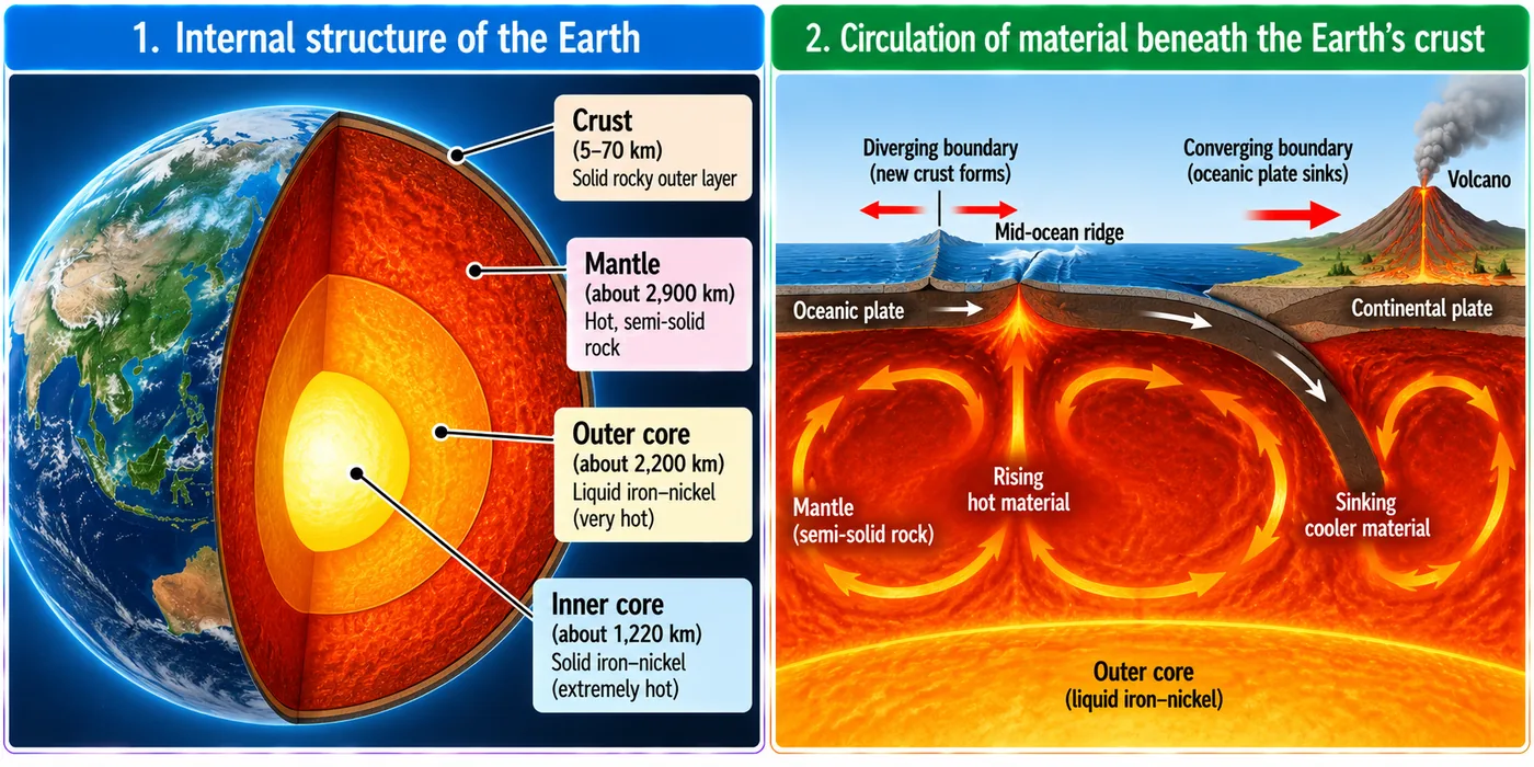
| Crust | 5–7 km under oceans; 30–40 km (up to ~70 km under high mountains) under continents | Thin, solid, rocky outer skin |
| Mantle | ~2,900 km | Mostly solid but very hot; flows extremely slowly |
| Outer core | ~2,200 km | Liquid iron and nickel |
| Inner core | ~1,250 km radius | Solid iron–nickel ball; densest part |
- The lithosphere = crust + uppermost mantle (about 100 km), rigid and broken into tectonic plates.
- Beneath it, the asthenosphere is hot, partly molten and weak, allowing plates to move.
- Convection currents: heat from the core makes hot mantle material rise and cooler material sink, slowly dragging the plates — usually a few centimetres a year.
3. Plate Tectonics
The theory of plate tectonics, developed in the 1960s by scientists including W. Jason Morgan and building on Alfred Wegener's earlier idea of continental drift, says the lithosphere is broken into large and small plates that move over the asthenosphere. Plates may be continental, oceanic or mixed. Major plates: Pacific, Eurasian, African, North American, South American, Indo-Australian and Antarctic.
| Boundary | Movement | Result | Example |
|---|---|---|---|
| Convergent | Plates move towards each other | Continent–continent: fold mountains. Ocean–continent: oceanic plate sinks (subduction), causing volcanoes and earthquakes | Himalaya; Andes |
| Divergent | Plates move apart | Magma rises, new crust forms, mid-ocean ridges | Mid-Atlantic Ridge |
| Transform | Plates slide past each other | Crust neither made nor destroyed; earthquakes | San Andreas Fault, USA |
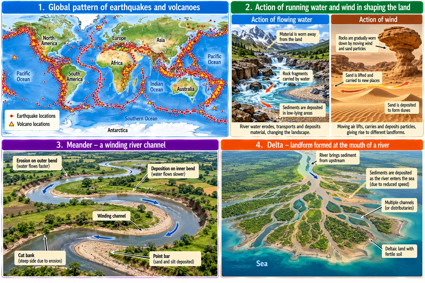
Most earthquakes and volcanoes occur along plate boundaries, especially around the Pacific — the Ring of Fire. India is earthquake-prone too: the 2001 Bhuj (Gujarat) earthquake caused massive destruction. Varāhamihira's Bṛihatsaṁhitā devoted a section to bhūkampa (earthquakes), linking them to observations of weather and animal behaviour. India's only mud volcano, at Baratang (Andaman and Nicobar Islands), bubbles mud pushed up by underground gas.
4. Weathering and Erosion
| Process | Meaning | Types / agents |
|---|---|---|
| Weathering | Breaking down of rocks in place — no movement | Physical (heating–cooling, frost, wind), chemical (reactions with water, air, acids), biological (roots splitting rocks, burrowing animals, microbes) |
| Erosion | Wearing away and carrying away of material | Water (rivers, rain, waves), wind, glaciers, coastal waves |
Erosion removes fertile topsoil (lower crop yields), washes away riverbank and coastal homes and roads, destabilises construction and mines, and harms tourism and fishing. India has old conservation wisdom: Harappan contouring, bunding, terraces, dams and canals; land assessment in the Arthaśhāstra; and Nagaland's Zabo system of earthen bunds and ponds on hill slopes. Today contour trenches, bunds, terraces and check dams slow water, hold soil and recharge groundwater.
5. Agents of Gradation and Their Landforms
Agents of gradation wear down high land and fill up low land, levelling the surface over time.
Running water (rivers)
- Upper course (steep): V-shaped valleys, rapids, waterfalls (hard rock over soft rock; tourism, hydropower).
- Middle course: meanders — erosion on the outer bend (steep cut bank), deposition on the inner bend (point bar); cut-off loops become oxbow lakes; fertile floodplains support farming and settlement (e.g. the Kallanai on the Kaveri for irrigation).
- Lower course: levees, alluvial fans and deltas — fan-shaped deposits at the mouth, very fertile (rice, jute), rich in fish, densely populated but flood-prone. The Ganga–Brahmaputra delta, home of the Sundarbans mangroves, is the world's largest delta.
Sea waves and currents
- Deposition: beaches, sand bars — tourism, fishing, natural buffers against waves.
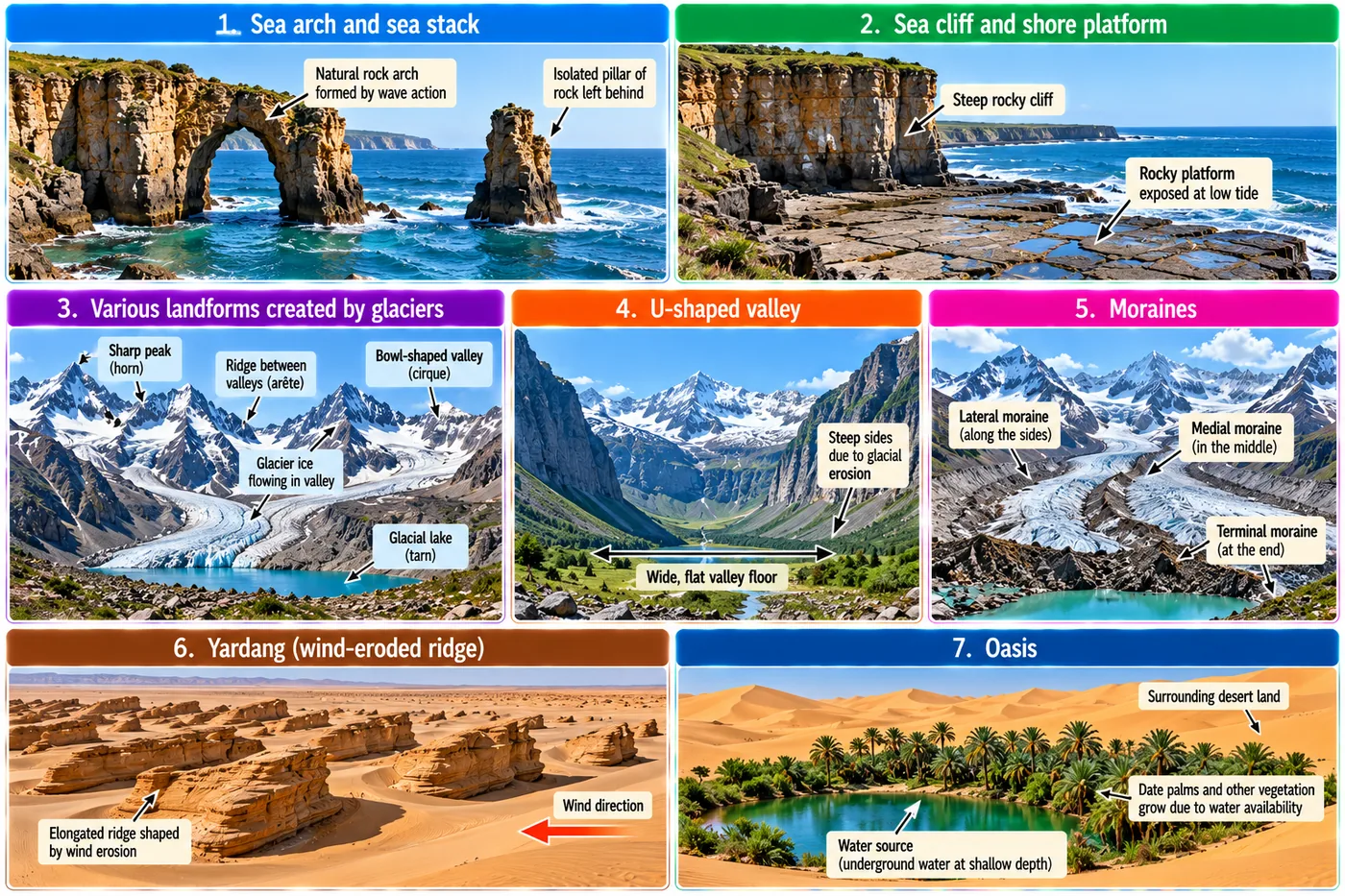
- Erosion: sea cliffs, wave-cut (shore) platforms, sea caves, arches (caves meeting through a headland) and stacks (pillars left when arches collapse).
Glaciers
- Erosion: U-shaped valleys, cirques (bowl-shaped hollows), arêtes (sharp ridges), horns (sharp peaks), hanging valleys, fjords (drowned glacial valleys), tarns (cirque lakes).
- Deposition: moraines of glacial debris (till) — lateral (sides), medial (middle, where glaciers join), terminal (end).
- Glaciers feed rivers that sustain people downstream; moraines can dam lakes.
Wind
- Erosion: yardangs (streamlined rock ridges), ventifacts (sand-blasted rocks), deflation hollows, desert pavements; where hollows reach groundwater, an oasis forms.
- Deposition: dunes — barchan (crescent), longitudinal (parallel to wind), star (multi-armed), parabolic (U-shaped, held by plants).
Groundwater (karst topography)
In limestone areas, slightly acidic water dissolves rock forming caves, stalactites (hanging from the roof), stalagmites (rising from the floor), pillars where they meet, sinkholes (dolines) and underground rivers.
Landforms shaped history: fertile river plains of the Indus, Ganga, Nile and Brahmaputra nurtured civilisations; the Himalaya protected India while passes like the Khyber allowed contact; deserts like the Thar limited settlement but carried trade routes; coasts and harbours helped south Indian kingdoms trade overseas.
6. Landforms and Disasters
| Disaster | Causes | Prone areas (India) | Mitigation |
|---|---|---|---|
| Landslides | Heavy rain, earthquakes, steep slopes, loose rock; deforestation, mining, road-cutting, poor drainage | Himalayan States, Western Ghats, Northeast | Afforestation, retaining walls, proper drainage, slope-safe construction, early warning |
| Avalanches | Heavy snowfall, weak snow layers, sudden warming, wind-loaded snow, vibrations from skiing or construction | J&K, Ladakh, Himachal, Uttarakhand, Sikkim | Snow fences, avalanche forecasting, closing risky routes |
| GLOFs (glacial lake outburst floods) | Glacier melt enlarges lakes dammed by ice or moraine; heavy rain, quakes or avalanches burst them | High Himalaya — e.g. the South Lhonak lake outburst in Sikkim (2023) | Mapping and monitoring lakes, controlled draining, early-warning systems, avoiding building in flood paths |
| Dust storms | Strong winds over dry, bare soil; drought; overgrazing and deforestation | Rajasthan, Punjab, Haryana, western UP | Shelterbelts of trees, sand-dune fixing, better grazing and farming practices |
In February 2021, a sudden flood in Chamoli district, Uttarakhand, triggered by a massive rock and ice avalanche high in the mountains, killed many people and wrecked roads, bridges and hydroelectric projects — a reminder of Himalayan fragility.
7. Master Table: Key Terms
| Term | Meaning |
|---|---|
| Landform | Natural surface feature formed by Earth processes |
| Lithosphere | Rigid crust + upper mantle, broken into plates |
| Asthenosphere | Hot, partly molten layer beneath the lithosphere |
| Convection current | Rising hot and sinking cool mantle material |
| Subduction | Oceanic plate sinking under another plate |
| Weathering | Breaking of rocks in place |
| Erosion | Wearing away and transport of material |
| Gradation | Levelling of land by erosion and deposition |
| Moraine | Glacial debris deposit |
| Karst | Limestone landscape shaped by groundwater |
| GLOF | Glacial Lake Outburst Flood |
8. Master Summary Table
| Agent | Erosional landforms | Depositional landforms |
|---|---|---|
| River | V-valley, waterfall, gorge | Floodplain, levee, delta, point bar |
| Sea waves | Cliff, cave, arch, stack, platform | Beach, sand bar, spit |
| Glacier | U-valley, cirque, arête, horn, fjord | Moraines |
| Wind | Yardang, ventifact, deflation hollow | Dunes, loess |
| Groundwater | Caves, sinkholes | Stalactites, stalagmites, pillars |
Chart — approximate thickness of the Earth's layers (km):
9. Mind Map
- Crust, mantle, core
- Lithosphere, asthenosphere
- Convergent, divergent
- Transform; Ring of Fire
- Physical, chemical
- Biological; erosion
- River, sea, glacier
- Wind, groundwater
- Landslide, avalanche
- GLOF, dust storm
10. Tips and Tricks
- Boundaries: Convergent = conflict (collide); Divergent = divide (apart); Transform = transit past.
- Stalactites hang from the top; stalagmites grow from the ground (m for mound).
- Valleys: V for river (V-shaped), U for ice (U-shaped).
- Weathering does not move material; erosion does.
- The mantle is mostly solid — only the asthenosphere is partly molten, and magma forms only in some places.
11. Important One-liners
- The crust and upper mantle form the lithosphere.
- Convection currents in the mantle move tectonic plates.
- The Himalaya formed at a convergent boundary.
- The Mid-Atlantic Ridge is a divergent boundary.
- The San Andreas Fault is a transform boundary.
- Most volcanoes lie around the Pacific Ring of Fire.
- India's only mud volcano is at Baratang.
- Oxbow lakes form from cut-off meanders.
- Glaciers carve U-shaped valleys.
- Barchans are crescent-shaped dunes.
- Zabo is a traditional conservation system of Nagaland.
12. Exam-pattern Questions with Detailed Answers
Which boundary forms fold mountains like the Himalaya?
- Divergent
- Transform
- Convergent
- Passive
Show answer
A convergent boundary where two continental plates (Indian and Eurasian) collide and crumple.
Answer: (C)
Icicle-like formations hanging from a cave roof are:
- Stalagmites
- Stalactites
- Pillars
- Sinkholes
Show answer
Stalactites hang from the roof; stalagmites rise from the floor; they join to form pillars.
Answer: (B)
Differentiate weathering and erosion.
Show answer
Weathering breaks rocks down in place; erosion wears material away and transports it through water, wind, ice or waves.
Answer: In-place breaking vs removal and transport
“Plate movements explain the distribution of earthquakes and volcanoes.” Explain.
Show answer
Plates grind, collide, separate and sink at their edges, releasing stress (earthquakes) and allowing magma to rise (volcanoes). So both cluster along plate boundaries — especially the Pacific Ring of Fire, mid-ocean ridges and the Himalayan–Alpine belt — while plate interiors are relatively calm.
Answer: Activity concentrates at plate boundaries
How does a meander form, and how can it become an oxbow lake?
Show answer
On a gentle slope, faster water erodes the outer bank while slower water deposits on the inner bank, so bends grow into loops. During a flood the river cuts across the narrow neck of a loop; the abandoned loop, sealed by deposits, becomes an oxbow lake.
Answer: Lateral erosion and deposition; neck cut-off
Why are deltas densely populated, and what risk do they face?
Show answer
Fertile alluvium supports rice and jute; fish are plentiful; river channels aid transport and trade. But they are low-lying and face floods, cyclones, storm surges and rising sea levels.
Answer: Fertility and trade; flood risk
How are deforestation and erosion connected?
Show answer
Tree roots bind soil and canopies break raindrops; leaf litter slows runoff. Cutting forests exposes soil to rain and wind, increasing erosion, landslides and silting of rivers; afforestation reduces it.
Answer: Without trees soil is easily eroded
Why do earthquakes occur frequently in the Himalaya, and can they be predicted?
Show answer
The Indian plate is still pushing into the Eurasian plate, building stress that is released suddenly as earthquakes. Exact time and size cannot be predicted reliably; scientists can map high-risk zones and estimate probabilities, so preparedness — earthquake-resistant buildings, drills, zoning — is the key.
Answer: Ongoing collision; not precisely predictable
Explain how sea arches and stacks form.
Show answer
Waves attack weak points of a headland, forming sea caves; caves on both sides deepen until they meet, creating an arch; continued erosion collapses the arch roof, leaving an isolated pillar — a stack — which may later wear down to a stump.
Answer: Cave → arch → stack
What causes GLOFs, and why are they increasing?
Show answer
Glacial lakes are held by weak ice or moraine dams; heavy rain, melt, avalanches, landslides or earthquakes can breach them, releasing sudden floods. Global warming is melting glaciers faster, enlarging such lakes and raising the risk. Mitigation: satellite monitoring, lowering lake levels, warning systems and avoiding construction in flood paths.
Answer: Dam failure of glacial lakes; warming increases risk
Plan to protect land in your area from erosion.
Show answer
Plant trees and grass on bare slopes and riverbanks; build contour trenches, bunds and check dams; terrace farms on slopes; use mulching and cover crops; prevent overgrazing; plant shelterbelts against wind; guide drainage away from slopes; involve the community and the panchayat; learn from traditional systems like Zabo.
Answer: Vegetation + water-slowing structures + good farming
13. Quick Revision Summary
- Layers: crust, mantle, outer core, inner core; lithosphere moves over the asthenosphere via convection.
- Plate boundaries: convergent (mountains, subduction), divergent (ridges), transform (faults); Ring of Fire; Bhuj 2001; Baratang mud volcano.
- Weathering (physical, chemical, biological) vs erosion; conservation — terraces, bunds, Zabo.
- Agents: river (waterfall, meander, delta), sea (cliff, arch, stack, beach), glacier (U-valley, cirque, moraine), wind (yardang, dunes, oasis), groundwater (caves, stalactites).
- Disasters: landslides, avalanches, GLOFs, dust storms; Chamoli 2021.